
Flood risk often occurs outside mapped floodplains, driven by localized conditions. Translating complex data into accessible, mobile-first tools helps communities better understand, prepare for, and respond to flooding in real-world conditions.
Key Takeaways
- Flood risk extends beyond mapped floodplains
- Localized flooding drives neighborhood-scale impacts
- Disconnect between modeled data and lived experience
- Accessible, mobile-first communication shapes decision-making
- Stewardship depends on informed, actionable understanding
Overview
Flooding is not experienced as a line on a map. For communities, flood risk is felt through street ponding, impassable roads, and water reaching homes in places not shown on commonly referenced flood maps. Valuable flood risk data is information people can understand, relate to, and use to prepare for conditions they are likely to encounter.
Much of the flooding residents experience occurs outside mapped riverine floodplains. Localized rainfall, shallow ponding in streets, and neighborhood‑scale drainage conditions often drive impacts that are not fully captured in FEMA flood mapping. These gaps can complicate public awareness and decision‑making, especially in areas where flooding is a recurring reality.
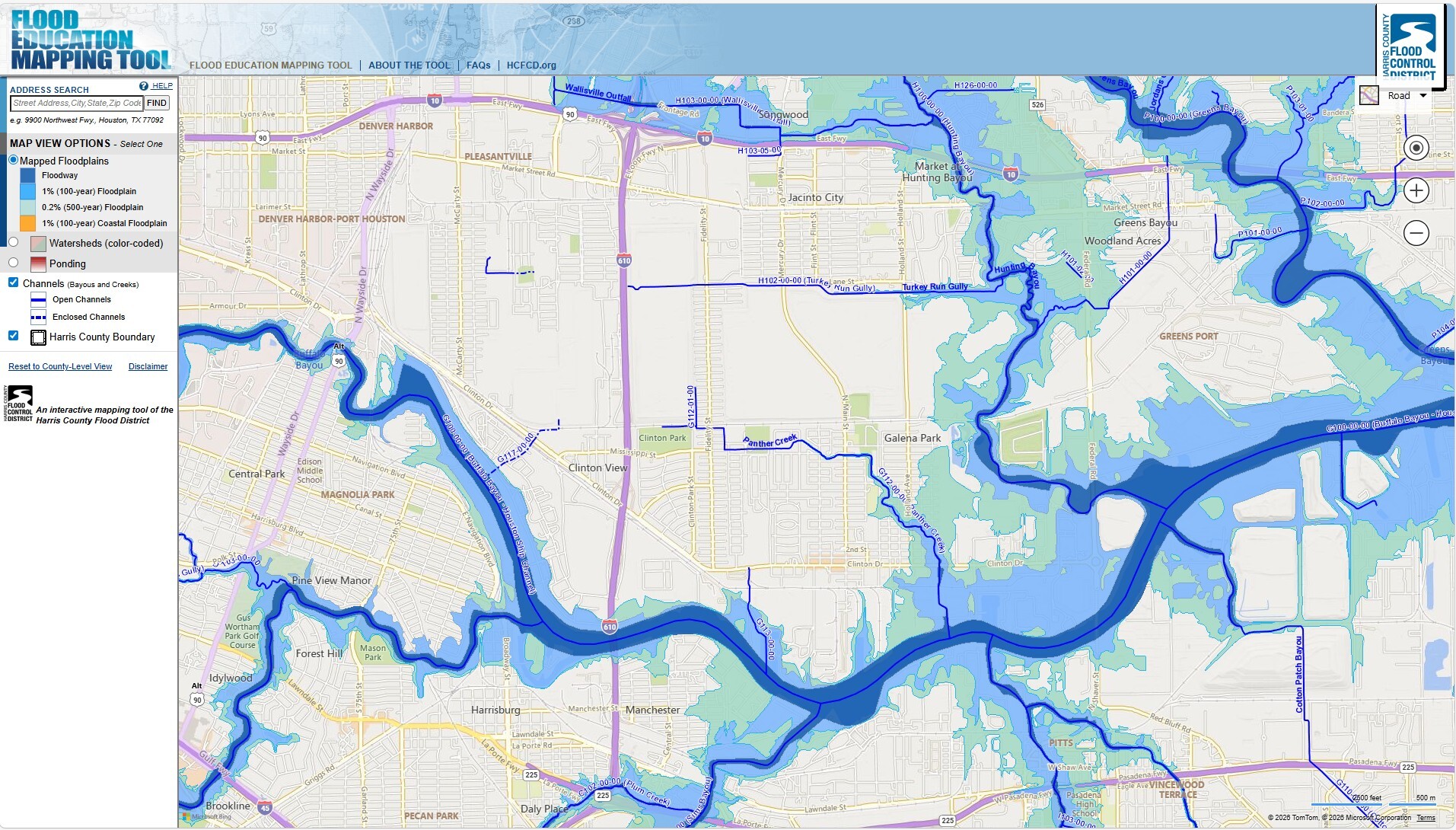
The Harris County Urban Flood Risk Pilot Study was developed to better reflect how flooding presents itself at the ground level. Rather than focusing solely on where riverine flooding is represented on FEMA flood maps, the study explores where and how localized, urban flooding does occur across neighborhoods, using data and communication tools designed to support clearer understanding.
Community Informed Engineering
The pilot study was led by the Harris County Flood Control District, with technical support from our floodplain management experts in collaboration with local stakeholders. The project focused not only on analyzing flood behavior, but on translating complex modeling results into information that communities can use.
Early coordination identified several priorities for effective risk communication. Flood risk information needed to remain consistent with existing county datasets and terminology, reflect flooding at a localized scale, and be accessible to residents under real‑world conditions. These discussions made one design constraint clear: during rainfall events, residents typically access information on smartphones, often while on the move. That reality shaped how the project approached communication from the outset.


Translating Data into Information
The primary outcome of the pilot study was the development of a web‑based interactive tool. The tool focuses on neighborhoods prone to localized flooding, where street and structure impacts can occur outside mapped floodplains. These areas were selected based on flat terrain, aging drainage infrastructure, and known localized ponding conditions common across Harris County.
Complex hydrologic and hydraulic modeling results are organized into clear, intuitive, interactive maps that work seamlessly on both desktop and mobile devices. The tool presents modeled flood depths across multiple storm durations and intensities, allowing users to see how different rainfall conditions affect their neighborhood. By distinguishing between short, intense storms and longer‑duration events, the tool clarifies how flooding can develop in different ways and at different times.
Roadway safety is also incorporated into the analysis. Using TxDOT depth-based safety thresholds, the tool identifies locations where modeled ponding may create hazardous driving conditions. Roads are classified by risk level, reinforcing that flood impacts extend beyond property damage to include mobility and public safety.
Users can explore specific locations within the pilot areas to compare ponding depths across storm scenarios. Together, these views reinforce a key takeaway: flooding does not stop at the floodplain boundary, and risk varies significantly even within a single neighborhood.
Supporting Informed Stewardship
A central objective of the Urban Flood Risk Pilot Study was to support more informed stewardship of flood risk through clearer communication. One example involves translating flood probability from an annual statistic into a cumulative 30‑year timeframe, consistent with a typical mortgage period. Presenting risk this way helps residents better understand the likelihood of experiencing flooding during their time in a home.
The tool also connects users to preparedness resources from FEMA and the National Flood Insurance Program. These encourage practical actions such as signing up for alerts, reviewing insurance coverage, and preparing for flood events before storms occur.
Flood mitigation infrastructure will always remain essential; however, flooding will continue to occur across places like Harris County, Texas. Stewardship requires more than building systems. It requires ensuring communities understand how water behaves locally and have access to information that supports better decisions before, during, and after storms. By pairing engineering rigor with accessible communication, the Urban Flood Risk Pilot Study helps lay the groundwork for long‑term resilience grounded in lived experience rather than lines on a map.


